


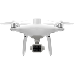
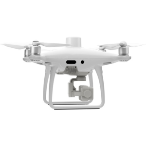
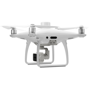
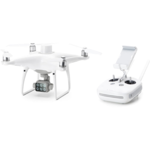
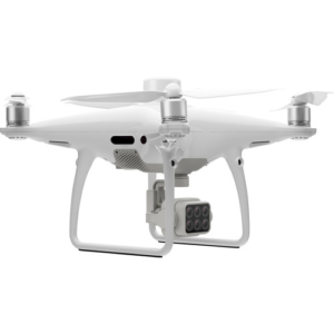


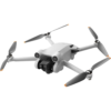
DJI P4 Multispectral Drone
Key Features
- Model: P4 Multispectral
- Effective pixels 2.08 MP (2.12 MP in total)
- RGB, Red Edge, NIR, Green, Red & Blue
- Up to 27 Minutes of Flight Time
- RTK Module for Accurate GPS Data
৳ 0
Out of stock
৳ 0
Out of stock
| Aircraft | ||
| Weight (Battery & Propellers Included) | Takeoff Weight: 1487 g | |
| Diagonal Size (Propellers Excluded) | 350 mm | |
| Max Ascent Speed | 6 m/s (automatic flight); 5 m/s (manual control) | |
| Max Descent Speed | 3 m/s | |
| Max Speed | 31 mph (50 kph) (P-mode); 36 mph (58 kph) (A-mode) | |
| Max Service Ceiling Above Sea Level | 19685 ft (6000 m) | |
| Max Flight Time | Approx. 27 minutes | |
| Operating Temperature Range | 0° to 40° C (32° to 104° F) | |
| Hover Accuracy Range | RTK enabled and functioning properly: Vertical: ± 0.1 m; Horizontal: ± 0.1 m RTK disabled: Vertical: ± 0.1 m (with vision positioning); ± 0.5 m (with GNSS positioning) Horizontal: ± 0.3 m (with vision positioning); ± 1.5 m (with GNSS positioning) |
|
| Gimbal | ||
| Controllable Range | Tilt: -90° to +30° | |
| Vision System | ||
| Velocity Range | ≤ 31 mph (50 kph) at 6.6 ft (2 m) above ground with adequate lighting | |
| Altitude Range | 0 – 33 ft (0 – 10 m) | |
| Operating Range | 0 – 33 ft (0 – 10 m) | |
| Obstacle Sensory Range | 2 – 98 ft (0.7 – 30 m) | |
| Operating Environment | Surfaces with clear patterns and adequate lighting (> 15 lux) | |
| Infrared Sensing System | ||
| Obstacle Sensory Range | 33′ / 10 m | |
| Operating Environment | Surface with Clear Patterns at >15 lux | |
| Camera | ||
| Sensor | Six 1/2.9” CMOS, including one RGB sensor for visible light imaging and five monochrome sensors for multispectral imaging. Each Sensor: Effective pixels 2.08 MP (2.12 MP in total) |
|
| Lens | FOV (Field of View): 62.7° Focal Length: 5.74 mm (35 mm format equivalent: 40 mm), autofocus set at ∞ Aperture: f/2.2 |
|
| ISO Range | Video:100-3200(Auto) 100-6400(Manual) |
|
| Mechanical Shutter Speed | 200 – 800 | |
| Electronic Shutter Speed | 1/100 – 1/20000 s (visible light imaging); 1/100 – 1/10000 s (multispectral imaging) | |
| Image Size | 1600×1300 (4:3.25) | |
| Supported File Systems | FAT32 (£ 32 GB); exFAT (> 32 GB) | |
| Photo | JPEG (visible light imaging) + TIFF (multispectral imaging) | |
| Supported SD Cards | microSD with a minimum write speed of 15 MB/s. Max Capacity: 128 GB. Class 10 or UHS-1 rating required | |
| Operating Temperature Range | 0° to 40° C (32° to 104° F) | |
| Remote Controller | ||
| Operating Frequency | 2.4000 GHz to 2.4835 GHz (Europe, Japan, Korea) 5.725 GHz to 5.850 GHz (Other countries/regions) |
|
| Max Transmission Distance | FCC / NCC: 4.3 mi (7 km) CE / MIC / KCC / SRRC: 3.1 mi (5 km)(Unobstructed, free of interference) |
|
| Operating Temperature Range | 0° to 40° C (32° to 104° F) | |
| Battery | 6000 mAh LiPo 2S | |
| Transmitter Power (EIRP) | 2.4 GHz: < 20 dBm (CE / MIC / KCC) 5.8 GHz: < 26 dBm (FCC / SRRC / NCC) |
|
| Operating Current/Voltage | 1.2 A @ 7.4 V | |
| Intelligent Flight Battery | ||
| Capacity | 5870 mAh | |
| Voltage | 15.2 V | |
| Battery Type | LiPo 4S | |
| Energy | 89.2 Wh | |
| Net Weight | 468 g | |
| Charging Temperature Range | -10° to 40° C (14° to 104° F) | |
| Warranty | ||
| Warranty | No Warranty | |
The DJI P4 Multispectral Agricultural Drone can be a useful tool in monitoring, understanding, and treating concerns connected to crop and vegetation health with information that is invisible to the human eye. This is true for both environmental research and agriculture. This drone can look below the surface since it has a gimbal with a 6-camera array. The other five cameras each capture a different wavelength, while one camera is an RGB camera that only records visible light and takes conventional images. The other five cameras record 2MP images in wavelengths including red edge, near-infrared, green, red, and blue. Even while flying at higher speeds, the resulting photographs are clear thanks to the global shutter and 3-axis stabilized gimbal. To maximize data collection and concentrate on the regions that require the most attention, you can flip between the two feeds while flying. An integrated spectral sunlight sensor on the top of the P4 Multispectral quadcopter works in conjunction with the gimbal camera to achieve the most accurate NDVI results possible. The sensor captures solar irradiance to help increase accuracy and maintain consistency in processed data through different times of the day.
The DJI P4 Multispectral Drone includes an RTK module that can be used to help increase the accuracy of GPS location data. The P4 Multispectral is compatible with the optional D-RTK 2 Mobile Station and NTRIP.
The DJI P4 Multispectral Drone’s real-time, centimeter-accurate data collection in imaging is made possible by DJI’s TimeSync system. TimeSync causes the P4 to continuously align the gimbal camera, RTK module, and flight controller, setting the location to the CMOS’s center. This helps offer the post-processing software for your photos incredibly precise metadata.
 AULA S20 Wired Optical Gaming Mouse
৳ 800
AULA S20 Wired Optical Gaming Mouse
৳ 800 Value Top VT-1290 120mm Black Casing Cooling Fan
৳ 350
Value Top VT-1290 120mm Black Casing Cooling Fan
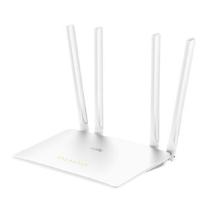
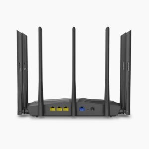
৳ 350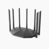 Tenda AC23 2033mbps AC2100 7 Antenna Dual Band Gigabit Wireless Router (Black)
৳ 3,900
Tenda AC23 2033mbps AC2100 7 Antenna Dual Band Gigabit Wireless Router (Black)
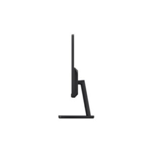
৳ 3,900 Xiaomi Redmi RMMNT215NF 21.45" FHD Monitor
৳ 9,500
Xiaomi Redmi RMMNT215NF 21.45" FHD Monitor
৳ 9,500 Razer Viper Mini Ultra-Lightweight Chroma RGB Gaming Mouse
৳ 3,600
Razer Viper Mini Ultra-Lightweight Chroma RGB Gaming Mouse
৳ 3,600


Reviews
There are no reviews yet.